


The Best road trip you could ever take.
"Love doesn't make the world go round. Love is what makes the ride worthwhile."
Franklin P. JonesYes, the best road trip while visiting Whistler in our opinion is to go north to Lillooet and west to Gold Bridge.
Now there is one consideration you must make before doing this trip. There is a section of road that is quite steep and when you must go around turns that to a nervous person could be quite intimidating. If you , or someone with you is bothered by this kind of experience, you’d better not go. The road is perfectly safe, but we don’t get to drive on this kind of road very often. Again, it is only for a fairly short distance that this condition exists.
Although the intent will be to drive there to the end and back there is a possibility of making a loop. It may be only suitable for vans or pickups.
Finally, 50 miles of this road will be a good quality gravel road, and you will need to return on the same road unless you do the loop as mentioned above.
This trip will take an entire day. It is a little over 400 km (250 miles) return. It is wise to pack a lunch as other than at Pemberton and Lillooet, there are no other places to eat.
Let’s Get Started
From your whistler mountain accommodations turn right onto the Sea to sky Highway number 99 and head north to Pemberton. You will pass Shadow Lake trail and Nairn Falls after crossing the railroad tracks about 17 km from Whistler. The descent into Pemberton is gradual and soon this beautiful town is yours to enjoy. Towering mountains aid in making Pemberton one of the most beautiful towns in Canada. Now you begin to realize why we believe this tour is the best road trip you will take anywhere.
Continue north through the First Nations Reserve of Mount Currie and along the valley with it’s gently flowing river. Once you pass a couple of small stores watch for the Duffy Lake sign on your right across from the church on the left.
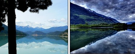
Anderson lake (left) and Lillooet Lakes
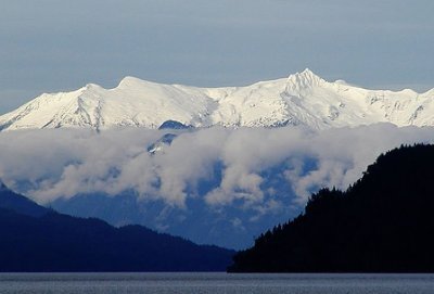
Soon the beautiful blue waters of Lillooet Lake greet you with gorgeous vistas of the surrounding mountains. Soon the road swings up hill to the left and a steady climb for the next few kilometers. There are good offs on the left where you may take in some fantastic views of the mountains. The road twists and turns as it rises, following Joffre creek as it tumbles along.
Pristine Duffy Lake
 Joffre Lake recreation area comes into view on your right. Shortly ahead you enter the high alpine valley where the cold, sapphire waters of Duffy Lake sit quietly on your left. Be sure to stop for photos of the Matier glacier and Joffre peak, dominating the scenery at the south end of the lake.
Continuing on your tour Coyoosh Creek flows swiftly along on your left and soon the canyon drive will enthrall you with its mile high sides framing the scene. Pull off areas allow for great photo opportunities of the creek and mountains. Watch for the Forestry Camping sites with picnic tables along the swiftly flowing creek.
The road climbs steeply, twisting its way along the creek as it navigates through the canyon.
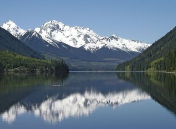
Now Lillooet comes into view. The beautiful Seton Lake comes into view. A great place to stretch your legs or have a picnic is available at the beach. Exit left to the lake if you wish.
Birkenhead Lake (left) and Seton Lake
BC Hydro
Seton, Anderson and Carpenter Lakes and Cayoosh Creek all for part of the BC Hydro power generating system. The canal taking the water to the generators is at the end of the lake.
The town of Lillooet
Now you come to the great little town of Lillooet. It’s been here for thousands of years. At one time 15,000 people lived here making it the most populated town in BC. This was back in the Gold rush days around 1860. This was on the original route where the prospectors made their way to find their fortune. Lillooet was named for the Lil’wat First Nations People. Lillooet was known as mile 0 on the trail leading north. Places such as 100 mile house remain today so named as the distance from Lillooet.
Once the highway was built through Fraser canyon bypassing Lillooet the population dropped but the town continued to exist. With the upgrading of Highway 99 and the best road trip is now a beautiful drive to Whistler and has brought the tourist industry to the forefront for Lillooet. Countless recreation possibilities have seen a resurgence in traffic to this beautiful and historic area.
 The best road trip to Gold Bridge begins at Lillooet. Follow the signs through the town and head out. As mentioned it is a gravel road but parts are slated to be paved, hopefully in the near future.
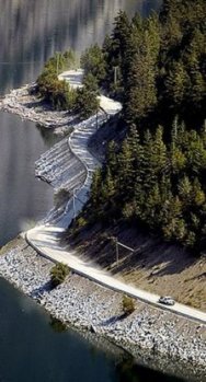
For the first part of this best road trip, the road descends and climbs up and over hills. The heavy snows of winter along with frost cause the side hills to loosen and rocks and mud sometimes come down on the road. The highways maintenance department clear the debris before summer, however you should drive carefully and remain alert.
As you round some of the high turns, it can be quite nerve racking, however, the road is quite safe.
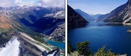
Carpenter lake is the lake you will travel around to get to Gold Bridge. It was created by damming the creek and flooding the valley as a storage reservoir for the BC Hydro generator in Lillooet. Once the spring runoff is over, the lake level drops significantly exposing tree trunks and sand bars.
Finally you arrive at the communities of Gold Bridge, Bralorne and Pioneer. Over the years thousands of miners and their families lived, worked and died here. Unless you are going to drive the loop this is where the best road trip terminates.
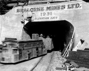
At it’s peak the population was 10,000. Bralorne mine produced incredible amounts of gold. In the first six years of its existence $375 million dollars (1930s dollars) worth of gold went into the coffers and it continued to be productive until 1971 when it was closed. It was the deepest mine in North America at the time over 8,000 feet from top to bottom.
Another mine was worked up the hillside from the main road at Pioneer. Bralorne eventually merged with Pioneer. It was thought the two mines were close together as their surveys showed but recently it has been determined there is a cubic mile of mountain separating the two. With the introduction of new mining methods and the high price of gold the mine is expected to re-open.
There is a small museum at Pioneer. There you will read about the history as well as see displays from the mining days.
Irma and I visited the area a couple of years ago in July. After our visit we decided to continue on the Hurley Road over to Pemberton. A local resident informed us that the best road trip was full of pot holes but that we shouldn’t have a problem with our van. He was correct. We did meet up with a fair amount of snow along the way but the road was plowed. Yes there were pot holes and plenty of them, but they were surface holes, not the “lose the car” size and all you need do is drive slowly. It is about 45 miles long.
There are some very nice views of the mountains and waterfalls along the way. Once you reach the crest of the mountain and start the descent down to Pemberton you will be rewarded with some absolutely gorgeous views of the lush green valley far below. This was the best road trip part of our trip.
On your return to Lillooet and home along the way you came, you may think that because you must drive on a gravel road and possible a little dust that you have it tough, consider this.
Naming the Lakes
In the spring of 1846 Alexander Caulfield Anderson was given the job of trying to find an easier route to travel from Kamloops to the lower Fraser Valley. The Fraser canyon was an extremely tough route and not the best road trip at that time. The Hudson Bay company wanted better access for a trade route. We hardly think they would consider this as their best road trip ever taken.
Anderson set out with five men and eventually arrived at Bridge River. He decided that the canyons on that river were too steep to travel and continued down south to Cayoosh Creek. There they decided to paddle to the end of Seton Lake and with the advice of the First Nations people they had met at Lillooet, made the short portage to Anderson lake. Early the next morning they set out and had good traveling. They then paddled the length of Birkenhead Lake. The next day they arrived at Mount Currie. There they met up with a small band of First Nation people who after a tough winter, were on the verge of starvation. After trading a little with them they paddled down Lillooet Lake, Tenas lake and Lillooet river to Harrison Lake and to the Fraser River near Mission.
About 20 years later this was the route gold miners choose to travel to Lillooet.
As a reward for his efforts, Anderson was allowed to name one lake after himself, Seton Lake after a Major Seton who, along with many others, drowned when their ship Birkenhead struck a reef off the Cape of Good Hope and sunk in 1852. Birkenhead Lake was named for the ship. He did so because of a family relationship.
Now to complete the best road trip we know of in the whistler area simply retrace your steps back to your whistler accommodations.
Eccentric multi millionaire who built a nuclear proof fortress on Cayoosh Creek.
Return From Best road Trip to Whistler Outdoors
